-
Sunsetting MapMe.At

It is with great sadness that I have to announce that I will be closing down the MapMe.At website in its entirety. From Friday 9th October 2020 you will no longer be able to access the site.
Why am I doing this now? The site has been creaky and old for many years now but I’ve left it running because I find it useful for myself. I even went to the effort of upgrading various parts of the software a year ago, but I stalled when it came to testing everything still worked and I never got around to releasing that.
A week ago I had a look to see if anyone is actually still using the site. As it turns out only a tiny number of people have actually logged locations for the entirety of this year. Even for my own purposes the only times I log locations directly with MapMe.At is when I’m at home, for everything else I use Swarm from Foursquare.
I truly feel sad doing this. I decided to take some screenshots of notable periods from the past 13 years that the site has been operating. Looking around the times that my two children were born, seeing the trace as I took my heavily pregnant wife to the hospital along the route with many, many speed bumps. Seeing what I posted to social media around those times, or just the normal life I was living before my son arrived, surprisingly, on his due date.
Personally I have a lot of memories tied in to the site and you may too, but unfortunately it is built on some really old technology and it really is time to turn it off.
Accessing your data
What does this mean for you? As mentioned above you will not be able to access the site from Friday the 9th October 2020. If you would like to take any screenshots of maps please do it before then. On request I will make available a dump of all of the locations that you have stored on MapMe.At. Please send an email to export@mapme.at to request this. To protect your data I will require that you respond to an email on the address that is registered with the site. If you need to change this email address you have 7 days to log in and do this! I will respond to emails on that address for 3 months after which I can no longer promise to help recover your data.
“How do I track my location now?”
For tracking check-ins your best bet really is just to go with Swarm. For tracking exercise activities then Strava and Runkeeper would be some of the obvious solutions. Really it does seem that you need to be tracking for a purpose and use an app related to that purpose. I know that the few users that continue to actively use MapMe.At are using it to track the travels of their yachts. For these people I’m not entirely sure what their best option would be but a good option appears to be the Adafruit IO APIs. I had hoped to write a blog post explaining how to do this, and may yet get around to it in the next few days.
If you have any other suggestions then let me know on Twitter and I’ll share them for everyone else to see.
“What about my WhereDial?”
Well the WhereDial was a fun project! It was a really interesting experience to design and sell my own hardware. It was even featured in this fantastic book - Designing the Internet of Things (which was written by some good friends of mine!)
Unfortunately taking MapMe.At offline does mean that these devices will no longer work. As far as I know the only devices that have been activated recently are the ones in my house and in my Dad’s house. I really would like to have an option to keep them running, but MapMe.At isn’t it, and until I get time to think of something then unfortunately these will have to remain offline.
The WhereDial was designed as Open Source hardware so if someone has one and wants to get it working again they can find the WhereDial Arduino code on GitHub.
Thank You!
Thank you to the people who have supported me, who have given feedback, or have simply enjoyed using MapMe.At. I’m sorry that I can’t keep it going but I hope you enjoyed using it over the years!
- MapMe.At Founder - John McKerrell
-
Place Changes & Anti-duplication
We’ve recently put live a few changes around how places are stored in our database so we thought a blog post was in order to bring you up to date.
We now treat places that we’ve pulled in from Foursquare and Facebook the same as other places in our database. In the past you wouldn’t be able to favourite a location that came from Foursquare, but now you can! When we import a place from one of these services we have always looked in our database for any similar places and tried to match them up. Unfortunately if the name is entered slightly differently or the location has been recorded differently then it’s quite possible that we won’t be able to match it. This is why we’ve now added the ability for you to mark places as duplicates yourself.
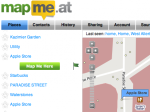 There’s two ways you can do this. If you’re accessing your main homepage through a regular browser then when you click on a location you will see the usual “Map Me Here” button but you will also see a new flag icon. If you tap on the flag we will confirm that you want to flag the duplicate and will then save that to the system. We review these reports regularly and will merge any duplicate places together. Don’t panic! If you’ve already checked into one or the other place we will update your old check-ins to point at the correct item.
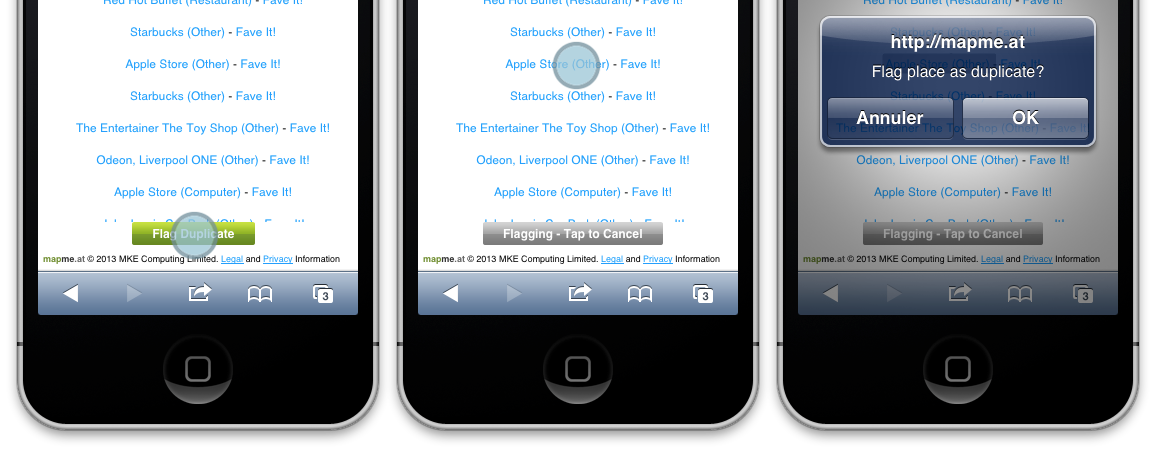
If you’re accessing our mobile site you will see a slightly different UI. Simply tap the button on the bottom of the screen, then tap on the place that is duplicated. If you tapped the button by accident just tap again and it’ll cancel.
We hope these changes will make the site easier to use and will help you to enjoy the site, and your WhereDials!
-
Bringing Internet of Things to Internet World 2013
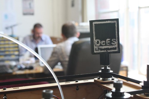
The following was originally posted on the DoES Liverpool blog. DoES Liverpool is a co-working space and community workshop in Liverpool, and is in fact where MapMe.At is based (our WhereDials are made on their laser cutter!) We thought you might like to hear about this so have, with permission, copied the blog post below:
You might think that “things” have always been connected to the internet. Computers, mobile phones, even printers have been connected for years. A lot of the current talk and investment in Internet of Things is large sensor networks and taking information from our environment. What we at DoES Liverpool like to think of when we talk about the Internet of Things is a whole lot more personal and unexpected. How about a bubble machine that blows bubbles when people mention you or your business on Twitter? Or perhaps a clock or dial that instead of showing time or statistics shows where someone is? These are just two of the ideas that members of the DoES Liverpool community will be bringing to Internet World this month.
But first, what is DoES Liverpool? We are many things. We are an online community of creative and often tech savvy people, of tech startups and “makers”. DoES Liverpool is also a physical space. It provides a co-working office space for members of the community to hot desk from or to take a permanent desk. There’s also a shared workshop with lots of equipment available for use; traditional tools such as soldering irons and band-saws to the more modern digital fabrication equipment like the laser cutter and 3D printers. We also hold regular events on many topics from specific programming languages like Python and Clojure through to more business focussed events like Lean Liverpool and Saturday Startup Club. We have a great community coming up with some wonderful ideas, and we’re looking forward to showing some of these to you at Internet World 2013.
Adrian McEwen has been putting things on the Internet for many years. He led the team who developed the first full web browser for a mobile phone, and his code (he’s slightly ashamed to admit) made it onto the Amstrad Emailer. He was recently described as an IoT pioneer by Kevin Ashton, the person who coined the term “Internet of Things” in the first place! Adrian will be bringing two of his IoT inventions to Internet World. Bubblino, the aforementioned twitter activated bubble blowing machine, was actually one of his first IoT projects but is well loved at conferences around the UK and has now been sold to various people in the UK and Europe. The Acker’s Bell was a more recent commision to provide Liverpool Startup ScraperWiki with a bell that would chime each time they made a sale. The mounting for the bell was designed and laser cut in DoES Liverpool with Adrian developing the software and electronics. Usually living in ScraperWiki’s office in Liverpool the Acker’s Bell will be visiting London for you to see at Internet World 2013
With another DoES Liverpool co-founder, Hakim Cassimally, Adrian has spent the last year writing the definitive IoT book - Designing for the Internet of Things. Both Adrian and Hakim will be available to discuss their book and IoT in general, and of course you can pre-order the book on Amazon!
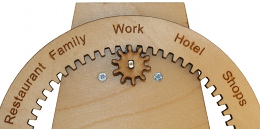
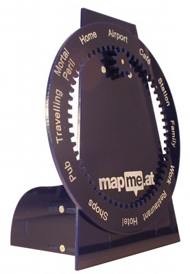
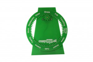
Inspired by the clock owned by the Weasley family in the Harry Potter books, the WhereDial provides a delightful way to make a personal connection with a family member or friend. The WhereDial is made from laser cut plywood or colourful plastic and features a list of location categories around the dial. Through the cloud based location aggregator - MapMe.At - the WhereDial can retrieve a person’s location from FourSquare, Google Latitude and a variety of other services. It then rotates the dial to show where the person is. It’s a great device for people who are less comfortable using mobile phones and computers but is also a really handy glanceable object that fits nicely on the desk of a technophile too. The WhereDial was designed and is built in Liverpool by John McKerrell, also a co-founder of DoES Liverpool.
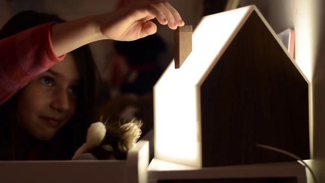
Perhaps saving the best for last, the final headline item that we’ll be bringing to Internet World 2013 is the Good Night Lamp. Darling of CES and Gadget Show Live, these lamps have a superstar team behind them. They are the brainchild of Alexandra Deshamps-Sonsino, previously a co-founder of smart product design studio Tinker London and the organiser of the monthly Internet of Things meetups in London. She launched the Good Night Lamp as a startup a year ago by committing to taking a booth at CES; 10 months of development later and with a live Kickstarter campaign garnering much publicity she took CES by storm. Her team includes our own Adrian McEwen as CTO; John Nussey as Head of Products and interior designer & architect Konstantinos Chalaris as Lead Designer.
We really hope you will enjoy our exhibition and go away inspired, potentially with some ideas for an IoT product of your own! DoES Liverpool is all about inspiring people to start interesting businesses and while our focus is in Liverpool, we know that IoT is going to take off around the world!
-
Latitude API, Mobile Web and Snappy Places
We’ve recently released some new changes which will provide more tracking options for everyone but may be of particular note to those of you with a WhereDial to update.
 The first thing to mention is our improved Latitude support. We are now plugging directly into the official Google Latitude API, rather than using their “Badge” API. This means that you can link your latitude account to MapMe.At without having to make your location public to anyone else. Google Latitude is a great way to track your location passively. Running in the background on Android and iPhone devices, Latitude will keep an eye on your location and let MapMe.At know when it changes. It does this intelligently too, using your device’s lower power systems to detect when the location has changed rather than running the GPS continuously.
With the Google Latitude API support we’ve also introduced some new attributes into logged locations: altitude, horizontal accuracy and vertical accuracy. We have also added functionality that means if someone provides us with a new location for you which has no place information but is very close to your previous check-in which did have a place attached, we will re-use that place information. There’s more technical information below but these changes should help to give you a cleaner trace with fewer instances of you bouncing between a place and an anonymous location as different services provide a location for you.
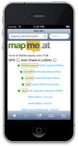 The final thing we wanted to mention is our mobile site, https://mapme.at/me/mobile. We don’t talk about it very much but this has been around for a while now and gives you a handy way to check-in to places near to where you last checked in or, if your device can provide a location, near to where you are now. Your nearby favourite places will appear at the top with other places appearing further down, closest first. It will even check you in automatically. If you select the second checkbox then once your device gets a location with an accuracy of less than 50 metres it will check you in. As ever MapMe.At will try to find a favourite place nearby or just store your anonymous location if necessary. If you leave this running while travelling it’s a great way to get a continuous trace with a little more accuracy than Google Latitude will provide.
We hope you enjoy these changes, let us know via twitter or Get Satisfaction if you have any problems. Read on for some more technical details.
Extra Technical Details
Before we made these changes we often found that our history could be “broken up” by locations provided by multiple services. For instance checking into Foursquare with a “shout” can result in a geo-tagged tweet. This could mean that your history would show a check-in to your favourite art gallery followed straight away by an anonymous location being logged moments later as the tweet would not be linked to the Foursquare check-in. The new changes mean that your tweet’s location would be detected as close enough to your previous check-in to be at the same location and the place information would be copied across. Note that this will only occur for a new check in and be compared to what MapMe.At thinks your current location is. Unfortunately right now it would be too intensive to check with historical check-ins.
We’re using the new horizontal accuracy information to define how close is close enough. Some services will provide locations with less accuracy, e.g. 5000m. This may seem useless however if it’s your first location in a new country then you will probably want to log the visit to a new country and be less concerned about the inaccuracy of the location. However if you haven’t really moved you obviously don’t want MapMe.At to think you are no longer at home, for instance, just because it has received an inaccurate check-in. If the service that we get the location from gives us accuracy information then we will use this to define how close your previous check-in needs to be. We’re only doing this with Google Latitude right now but we will extend it to other services in the future.
-
We Have a New Wiki
To try to improve the management, and quantity, of documentation on the site we now have a wiki! You can find it at https://mapme.at/wiki
You will need to log into MapMe.At to access the wiki but once in you will be able to view, and edit, all the documentation that we have.
We’ve copied across all the content that was previously on this blog and supplemented it with some new information. There’s still plenty more that we need and we’d love your help. What mobile apps do you use? What ways have you found to show your location? Have you built a delightful little hardware device for showing your current location? ;-)
We can’t wait to see what updates you make, remember you’re welcome to edit any pages on the site so if you come across a mistake or typo in a page, just fix it! Your name and MapMe.At username is attached to all your edits so do please keep it clean :-)
As a little addendum, have you seen that we’ve been nominated for the Postscapes Internet of Things Award 2012, in the Connected Home category? Take a look and, if you think we deserve it, vote for us!
-
WhereDial Now Available to Buy!
 We’re so glad to announce that we are ready to start shipping WhereDials!
If you haven’t come across the WhereDial yet it’s a cute “Internet of Things” device that you can use to connect friends and family to your daily life, or to keep yourself connected with your loved ones. You simply power it on and plug it into an internet connection. It then rotates the dial to show the location of the person at the top. Whether you’re in work, at home or in the pub, the WhereDial has you covered.
If you buy a WhereDial now we’re going to try our best to get it to you by Christmas so you will receive a dial with a standard set of locations with the option to buy customised dials coming in the new year. It’s still early days for the WhereDial project. Now that we’re happy with the hardware we’re putting our focus back on the MapMe.At website that supports it. We’re planning to add full support for Google Latitude and Facebook, and will be improving support for Foursquare and Twitter.
For more information take a look at the WhereDial page or to buy one head over to the WhereDial shop!
About Pre-orders
 Last year we invited you to order a WhereDial and started collecting details, including name and address. We were originally intending to use this to send out invoices but felt that as a year had gone by this would not be appropriate. It also wouldn’t give you much option to pick a colour and material that you liked. As such we will be taking no further action on those “orders”. We did not take any money previously and so would ask that if you did order before and still want to buy a WhereDial then please head over to the shop to complete a purchase there.
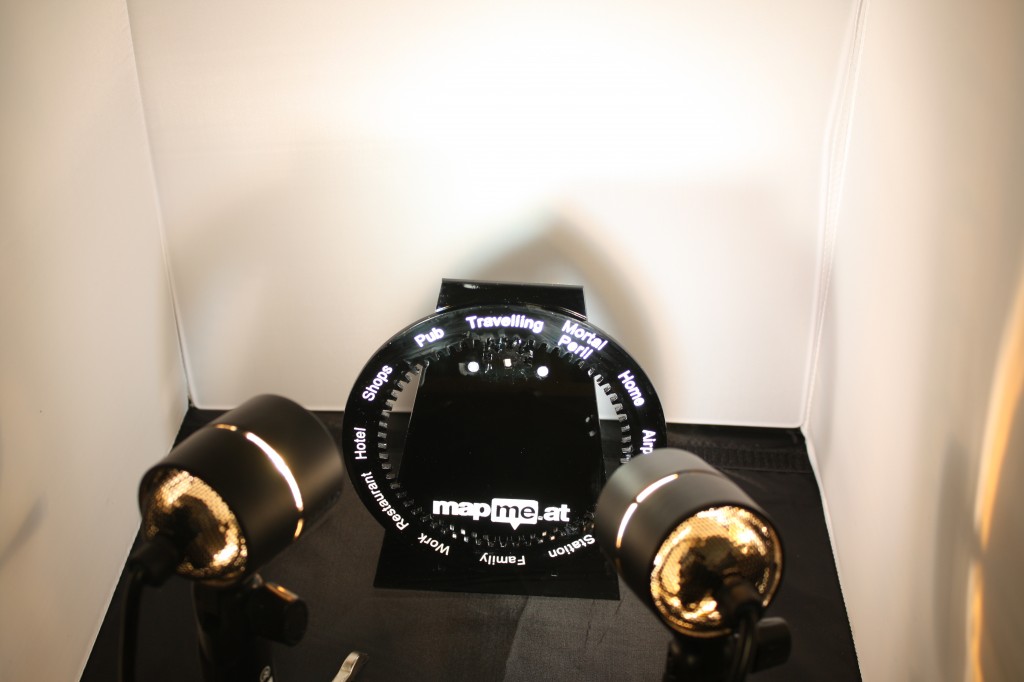
-
It's Good to Share
We’re glad to be able to announce a new feature on the site (yes, the first real new feature in a while!) - Sharing Codes.
The idea behind sharing codes is that a lot of people will want to share their location with friends and relatives who may not want to sign up to mapme.at, we recognise that and wanted to give you a way to share your location with some people while keeping your default public settings to something more restricted.
To get started log into mapme.at and click on the new “Sharing” tab at the top. You’ll be taken to a page that should look familiar, it shows you your current group accuracy settings but below you’ll also see the new “Sharing Codes” section:
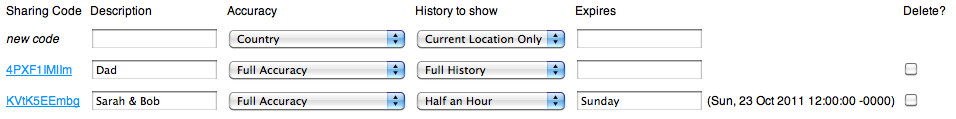
It’s quite a big form but don’t worry, it’s quite simple really! The only thing you absolutely must enter is a description; this gives you a way of tracking what sharing codes you’ve created, whether it’s one for your parents, friends or perhaps even an employer, simply enter a description and save and you’ll get a new sharing code. We recommend that you create a new code for each person or purpose, that way if someone finds out one of your codes you can easily delete it and create a new one. The other fields let you specify how long the code is active for and the accuracy and amount of history to show, here’s a full breakdown off the sharing codes:
Sharing Code
This is the actual sharing code you'll be giving out. Most people will simply want a link to the history page so that's the link we give you, the sharing code can also be used with the API, more about that later.Description
A short description so that you remember who you gave the code to.Accuracy
The level of accuracy you want to show for this code. Standard options from "Country" to "Full Accuracy", you can also set "No access" if you want to disable a code for a time.History to show
Perhaps you're happy for someone to see your current location but you don't want them to be able to see everywhere you've ever been. This setting allows you to restrict how much of your history they can see.Expires
If you want the sharing code to expire after a while enter a date and time in this setting. Various plain text times are accepted, once the code has been saved we'll show you the accurate time we've determined. We won't recalculate this until you edit the text. If you don't enter anything for this then the sharing code will be active indefinitely.Delete?
Want to delete a sharing code? Check this box and click "Save" below.Remember that you must only share these codes with people you really want to see your location. If anyone else finds out a sharing code they will be able to see your location.
As mentioned above the sharing codes can be used with the API, simply pass
sharing_code=[SHARINGCODE]and the API will your return your history to the level of accuracy you have specified. This is great for simpler applications where full OAuth access would be overkill. You can also use the sharing code with the export API but remember that if you put a sharing code on a webpage, even in the HTML, others will be able to read it and read your history, perhaps to a greater level of detail than you intended.So play with the codes and let your family and friends find out where you are! As this is pretty fresh code there may be bugs so if you spot anything, let us know!
-
State of the Map 2010
This past weekend saw the annual OpenStreetMap “State of the Map” conference arrive in Girona, Spain. I attended for the fourth year running and was glad to be given the opportunity to talk about mapme.at, what it is and how it uses OpenStreetMap data.
I started by giving a brief overview of the site, the functionality offered and how we integrate with many other services. I then went on to describe mapme.at as a “Social Location Experimentation Platform”. My idea behind this concept is that mapme.at gives people many ways to experiment with their location. On the one hand it allows regular users to experiment by trying out various services that become available. As an example, someone might decide to try Google Latitude out, perhaps as they’ve just got a new android phone. After a few weeks this person might decide that latitude isn’t offering what they want, perhaps they prefer the badges and mayorships of Foursquare. If they’ve signed up to mapme.at they can store all of their locations in our database where they will be available to the user to download or use in the future. In this way users can experiment without having to think “there’s no point trying this service out as I’ll just stop using it after a few weeks”.
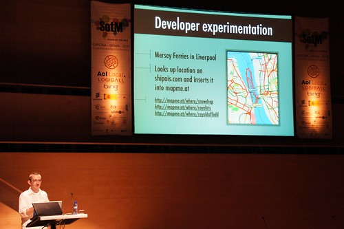
The other type of experimentation is developers experimentation. Developers can use our API to experiment and produce all sorts of great apps. I mentioned the ferry trackers as an interesting example of putting data in, and then the “Weasley” clock as a fun example of pulling data out.
I also discussed some new functionality that we’re hoping to launch soon. Currently though we use OpenStreetMap as our canonical source of place data, there’s actually three sources that places might come from. If you’ve been using OpenStreetMap since before we launched the places functionality you may have added favourites for places you went to. Many of these favourites are public places that are now covered by the OpenStreetMap places. Part of the new functionality will allow you to merge your old favourites with the OpenStreetMap places meaning you’ll have a single set of logs all attached to the same place. If you’re using Foursquare you may have noticed that we do try to match their “venues” onto our places. Sometimes this isn’t possible though and if you’re using both mapme.at and Foursquare to check in you’ll sometimes find you’re logged at two separate places. The second part of the new functionality will allow you to manually match Foursquare venues onto our places so again you end up with all your logs attached to a single place. The result of this piece of functionality should be a big database of mappings between Foursquare venue IDs and mapme.at place IDs, and by extension OpenStreetMap IDs. We fully intend to release this data when it becomes available and we think this will be a good useful dataset for many people.
How I built a location-based social app
View more presentations from johnmckerrell.
If the talk sounds interesting you can find my slides on slideshare or see them above. I believe all the talks were recorded too so videos should go live eventually. I’ll finish off by thanking the people who organised the conference. It really is one of the best conferences covering location and all things geo and they really did a good job of pulling everything together. The only thing left is to ask where will State of the Map 2011 be?!
-
O'Reilly Where 2.0 2010
This week we’ve been at the Where 2.0 conference in San Jose, California. We submitted a talk and were fortunate enough to have it accepted. The talk was “Why I Track My Location and You Should Too” and involved John McKerrell, the founder of mapme.at, talking about his experiences of tracking his location and some insights he’s found over the years. We’ve put the slides for this presentation live on slideshare in case you want to take a look.
As part of this presentation we got in touch with the great people at ITO World. They’ve created some great graphics and visualisations in the past such as the OpenStreetMap Year of Edits image and video, and the OpenStreetMap response to Haiti earthquake video. Knowing that they can create some amazing work we asked them “What could you do with three years of personal location data?” In just a few weeks they came up with some really impressive visualisations.
All trips taken in the past 3 years from John McKerrell on Vimeo.
That image shows every single trip taken by John and stored in the mapme.at database. It shows all trips visible at once which is great on a global view but perhaps you’d like to see something a bit more close up, here’s every trip in London with all days shown at the same time:
All my travels in London run at once. from John McKerrell on Vimeo.
There’s more videos available, take a look at the slides on slideshare or on vimeo to see them.
We’ll be at the WhereCamp in Google’s offices in Mountain View this weekend. If you’re there say “Hi”, we’d love to discuss location tracking and visualisation with you.
-
Foursquare Support Now Available
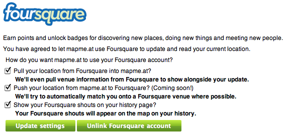
We’re happy to announce that we now have support for linking your account to Foursquare. If you haven’t tried it yet, Foursquare offers points, badges and more when you “check in” to locations.

We’ve still got some things to finish up to complete the support but right now you can go to your Sources page and link your account to Foursquare there. You have three options for how we’ll work with your Foursquare account. You can choose to let us pull your location from Foursquare which means that all your check ins get pulled into MapMe.At. Where possible we’ll match the Foursquare Venues onto our own places but where that’s not possible we’ll create an entry on our site to allow you to show people exactly where you are. You can also choose to make your “shouts” visible so people can see what you were doing when you checked in.
We will be adding support to push your locations from MapMe.At back into Foursquare soon so if that sounds good, just check the box when you link your account and we’ll start pushing locations over as soon as that’s ready. Again when we push locations into Foursquare we’ll try to match our places onto theirs where possible.
If you have any problems let us know over on Get Satisfaction or by mentioning our twitter account.
 There’s two ways you can do this. If you’re accessing your main homepage through a regular browser then when you click on a location you will see the usual “Map Me Here” button but you will also see a new flag icon. If you tap on the flag we will confirm that you want to flag the duplicate and will then save that to the system. We review these reports regularly and will merge any duplicate places together. Don’t panic! If you’ve already checked into one or the other place we will update your old check-ins to point at the correct item.


subscribe via RSS or via JSON Feed