-
Place based locating
You may have noticed that we recently launched some new functionality on the site. In the past when you wanted to map yourself you had, essentially, two options for describing that place. If you had some way of finding out the latitude and longitude for where you were you could give us that, or you could create a “favourite” which would give you a nice handy label to use instead and let you give a small description of where you were. We thought the favourites were a good way to attach something small and memorable to your location and make it really easy to map yourself wherever you are in the world by using Twitter, web or even DNS. If you didn’t have a favourite created in advance though it could be quite difficult to log your location if you didn’t have a GPS device or something similar though. We’ve now taken a big step towards making it easier to map yourself, whether you’re in the office, in the pub or in any of millions of places around the world by introducing “Place based” locating to mapme.at.

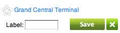
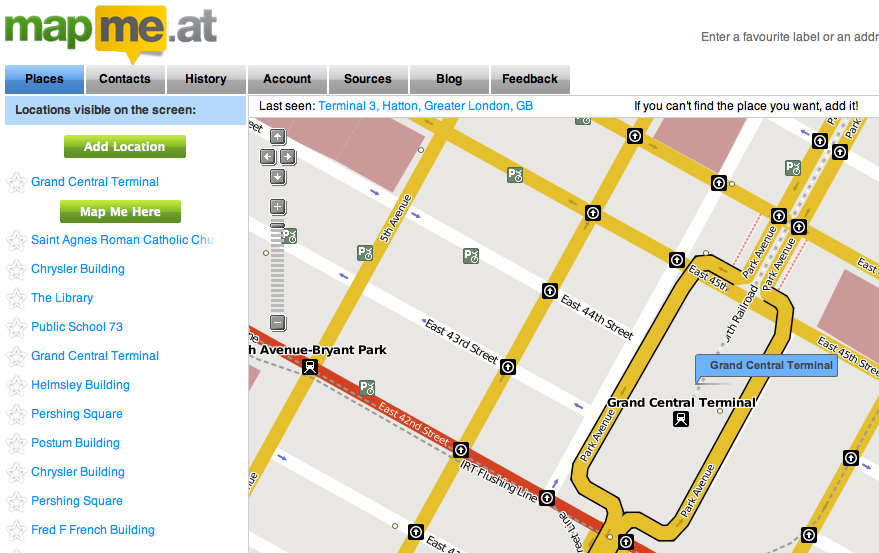
So, what does this mean? On Wednesday we pushed out an update to the site that gives you access to a huge database of places of interest. If you go to your homepage you’ll now see not just your favourites showing up but also other places from our database. These places will be listed on the left hand side under your favourites. They’re also displayed on the map as subtle little dots. Click on one of the places, either on the map or the text on the left to open up the place and map yourself there. You can also mark any of these places as a favourite by clicking on the star in the left hand side, optionally giving it a label, and clicking save.
 Don’t worry about your existing favourites, these have all been converted to private “places” and we’ve marked them as your favourites.
By default your homepage will centre on the last place that you mapped yourself to but if you’ve moved on from there you can either pan the map to your new location or use the search box on the top right. Remember that when searching more information is good, rather than just using “Market Street” something like “Market Street, San Francisco” is always going to give you better results.
If you have a browser that supports geolocation such as Firefox 3.6 or if you have Google Gears installed you should see a link marked “Find Me!” at the top right. If you click on that we’ll ask your browser where you are, it should ask for your permission and then we’ll move the map to where you are and show you some places nearby.

You might notice we’ve added a description of your current location to the top left of the map. This will remind you of where we think you are but you can also click on it if you want to bring the map back to your current location.
We source these places from OpenStreetMap, using the fine APIs provided by CloudMade. This gives us a constantly growing database of millions of places across the globe. Even so, nobody’s database is perfect so you might find that the place you’re at isn’t available. If this happens you can easily create a new place by clicking on the “Add Location” link on your homepage.
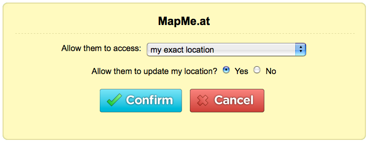
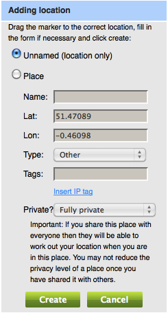 If you mark the location as “Private” then nobody else will be able to map themselves there - you might like to use this for your home. If you share the location with your contacts then any contact that has full accuracy to view your location will be able to map themselves there. You can also share places with everyone, and if you do this we’ll even push these back into the OpenStreetMap database so everyone benefits!
With all this going on we’ve still found time to create a mobile tailored web page which is great to use on iPhone and Android devices, and should work fine on anything with a modern mobile browser. Go to http://mapme.at/me/mobile and you’ll be shown a description of your current location and a list of nearby places. If you click on the GPS link it will look-up your location from your phone’s GPS or location services (assuming your phone supports this) and update the nearby places. If you click the checkbox marked “Auto” then we will monitor your position and update the places as you move. When you see the correct place in the list just click on it to map yourself there. If you click the second checkbox we will even log your location continuously if we have a location accuracy of less than 50m. You can still map yourself at your favourite locations using labels like “mapme.at/home” and do “on the fly” searching using something like mapme.at/Constitution Hill, London - this is great for mobiles that don’t support JavaScript
If you’re using our API you’ll find that the methods relating to “favourites” will no longer work. Favourites as they used to work no longer exist on mapme.at. From now on everything will be about places. API methods are in place for accessing places right now though and can be used by simply replacing “favourite” with “place” in the URL.
So we really hope you enjoy the new functionality and find it useful. There’s more to come but please feed back to us any comments you have!
-
Cycling 800 miles to Copenhagen
The problem with holding an international conference on climate change is the huge amounts of carbon dioxide that will be generated by all the attendees getting to the event. In the case of this week’s conference that means people crossing the globe to get to Copenhagen. One person from the UK decided there had to be a better way and decided to cycle the 800 miles from Birmingham to Copenhagen!
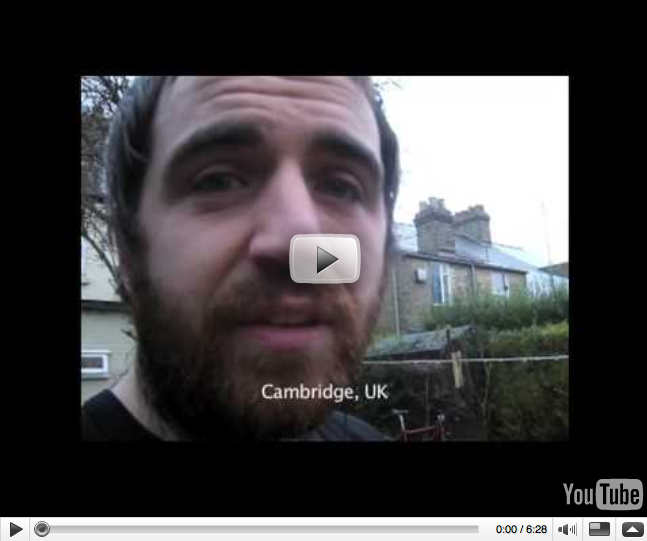
Darran Martin is part of the UK Youth Delegation to Copenhagan (UKYCC), 23 people from across the UK who are attending the summit trying to urge negotiators and World leaders to push for a deal which guarantees our futures.
If you take a look at the video linked below you might notice that Darran took with him two GPS devices. Our friends at Cloudmade donated a SPOT Satellite GPS Messenger and we at mapme.at gave him a Holux GPSlim 236 device working together with a Sony Ericsson k750i to use. As is usual with technology there was still a few hitches so we don’t have a very detailed trace but you can take a look at Darran’s History over the last week and get an idea for just how far he had to travel.
Getting 23 people from the UK to Copenhagen isn’t cheap, getting a group from Kenya to Copenhagen is even worse. The UKYCC are accepting donations to help them cover the cost of both these trips so any donations will be gratefully received.
Take a look at the site for a fun video made by Darran on his trip across Europe and then don’t forget to donate too!
-
Interesting Location/Clock Mashup
Update 16/12/2011: You can now buy one of these, go here for more information about WhereDial!
John McKerrell has blogged about a hardware hacking project he recently created mashing his location up with an old fashioned clock using an Arduino circuit board. The “Harry Potter” style Weasley clock has the names of favourites shown on the face of the clock and the hands of the clock move to point at his current location. Take a look at the video below or head over to his blog for more information.
-
Google Latitude now supported
Google Latitude is one of the increasing number of “location based social networks”. Google’s service is currently very simple, you can update your location via a mobile or on the web, you can then share your location with specific friends either at a city level or at full accuracy. They recently added a “Public Location Badge” that you can add to your blog to show your location to everybody that visits (we launched a similar service earlier today). Along with this they’ve also added a JSON feed that developers can use to pull your location into third party services, which is great news for us.
To use Google Latitude with mapme.at you’ll need to start by signing up for Latitude and enabling the Public Location Badge. On the page for the badge you should see a link entitled “Public JSON Feed”. Copy that address and then head over to your Location Sources page on mapme.at, scroll down the page until you find the Google Latitude section, enter the address in the box and you’re all set! Within a few minutes we’ll start requesting your location from Latitude.
Unfortunately, for mapme.at to be able to pull your exact location from Google Latitude and build up an accurate history, you will have to enable full public access to your location on Google Latitude (note that you can still hide your location in the standard ways on mapme.at). Obviously this is not ideal but until Google enable an authentication system or some better way of sharing your Latitude location, it’s all that we can offer to you.
One of the really good things about Google Latitude is that their mobile software already runs on so many phones. Already running on most Symbian S60 devices, Windows Mobile 5.0, colour BlackBerry devices and more, it’s quite likely that you’ll be able to run the software on your phone. The obvious omission of course is the iPhone but we already support InstaMapper’s GPS Tracker application and Thom Shannon’s novel email-base location tracking method for iPhone users so that shouldn’t be much of an issue.
-
Show your location on your blog or other websites
So we’ve been working on the history page to try to make it a good way to see where you’ve been and to share your location history with friends. There’s more improvements to come but you might be thinking “yes, the history page is good, but I want to be able to show my location history on my own website.” We’ve now got a couple of ways to let you do this. The first that we’ll talk about is a plugin for the Drupal content management system, the second is something you can use with any website.
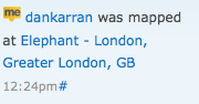 Dan Karran has written an integration module for the Activity Stream module of Drupal. If you take a look at the blog post you should be able to get this module installed and tell people where you are.
The other method to share your location is with the new “Export” feature of our API. To use this you just need to add an iframe to your page linking through to the new page with a URL such as
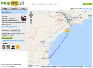
https://mapme.at/api/export.html?usernames=thebox. You can pass one or more usernames as you see fit (separated by commas), you can also pass arguments to specify the time and date that you want to show locations from, using similar arguments to the API ‘where’ method. Here’s a page showing history for “The Box” from the BBC over the past 3 months:https://mapme.at/api/export.html?usernames=thebox&mode;=since&since;=3%20months%20agoIf you only pass usernames in then the page will show the current location of the user and as already mentioned you can also link to multiple users. Here’s the map showing the current location of the ferries on the River Mersey in Liverpool, GB:
https://mapme.at/api/export.html?usernames=royaldaffodil,royaliris,snowdropThe export method uses the same security precautions as the rest of the site so if you want to use it to show your location to members of the public you may need to change your location sharing preferences, as always only expose as much information as you feel comfortable with. There’s more information about this on the documentation page for the export method so take a look there and then try it out!
-
Add a user profile to put life into your history page
We’re glad to announce that we’ve just released a code change which allows you to enter a user profile onto mapme.at. Go to the Account page and you can add a short description of yourself, a link to your website and even upload a picture of yourself. We recommend doing this as it will add real life to your history page. We’ve even made it easy for you by adding the ability to pull your existing profile information across from twitter.
At the same time we’ve also modified the history page so that you can see the list of contacts for the person who’s history you’re looking at. This should make it really easy for you to build up your list of contacts by seeing who your friends are in contact with and adding them yourself.
If you’re updating your profile please remember that everything you put in there will be visible to anyone, even people who have not signed up to mapme.at or made contact with you, only enter information you’re happy for everyone to see.
 So head over to your account page now and get uploading or importing. Let’s banish the orange question marks as soon as possible!
 -
The Future of Online Location Tracking?
You’ve probably noticed by now that mapme.at has had a bit of a makeover recently. This was all done as part of a changeover to using mapping services from CloudMade, a London and San Francisco based company aiming to bring the power of crowd sourced data from OpenStreetMap to more people. CloudMade were so impressed with our integration of their services that they asked us to speak at their recent developer launch events. We decided to take that opportunity to make a few announcements that we hope you’ll be excited to read about below.

Great New Look and Feel
For our new design we enlisted the help of the great team at Cogniance. They worked with us to provide a new logo and overall look and feel. They also gave us some ideas for improvements to the user experience; many of these have been implemented already but some are still on the list to be completed soon. We’re really happy about how the new look has turned out, the bright colours really inject life into the site and the fact that we’ve been able to tie these in with the map is just amazing, more on that in a moment…
CloudMade Integration
So far we’re taking advantage of just a few of the great services that CloudMade provide. In the previous section I mentioned the fact that we have been able to link our colourscheme into the colours used in the map. This is possible due to the groundbreaking new “Style Editor” tool from CloudMade. With this you can edit the styles used in the map to your heart’s content. Our map style was based on one that CloudMade call “The Original”, this looks really nice and only required us to spend a short time playing with the style editor to get it coordinating with our colours.
We’re also using the Geocoding services that CloudMade provide. Geocoding is the process by which a computer takes a written address, such as “10 Downing Street, London” and converts it to a latitude and longitude. We use this service on the homepage to make it easier for you to find your current location and create favourites, and with the twitter integration when you’re out and about. We’re really happy with the results we’re seeing from this service and we know that CloudMade are working hard to make it even better.
By using the unique OpenStreetMap dataset CloudMade are able to provide some really good services giving us access to the data at a very low level. We’ve got some ideas for how we can more closely integrate them into the services we provide on mapme.at and you should see these developing over the coming months.
You may notice that OpenStreetMap and therefore CloudMade do not have street level coverage worldwide. It’s actually the case that no mapping provider currently has coverage throughout the world and, similar in some ways to those providers, OpenStreetMap has some areas with better coverage than others. The one big difference is that if you find that the coverage around the locations that you visit often is lacking, you can get involved with improving this. We at mapme.at are big fans of the OpenStreetMap project and have been contributing for a number of years. We whole-heartedly recommend that you get involved, you might want to try signing up to their mailing lists or just take a look through their “wiki” to find out how to get involved.
New OAuth Developer API
At mapme.at we’ve always tried to make it as easy as possible for you to update your location. We already provide integration with Twitter and with FireEagle. You can update your location through the web, via email or even using DNS. So far though all of these integrations have required us to do most of the work on our side, meaning that you couldn’t use a new method, such as a new mobile app, until we had done some work integrating it. We are now opening up an API (Application Programming Interface) so that any developer can sign up and integrate their application with the mapme.at site.
An API is essentially a set of instructions and methods that we give to developers that tell them how to access our website and update the data that we store here. Obviously it wouldn’t be very good if just anybody could access all the data we store, or change everybody’s data so to stop that we use authentication. We’ve decided to use the OAuth authentication scheme to make sure that we take the best possible care with your data, while allowing you to make the most of third party services that will enrich your experience of mapme.at. OAuth allows you to give permission to a third party service to access or update your data on mapme.at without you needing to give them your username and password. This means that if at some point in the future you decide that you don’t want this service having access to your data, you can simply revoke that access from our website. If, for instance, you gave a mobile app on your phone access to your data, and then lost your phone, you could still revoke the access even though you can’t use your phone.
If you’re interested in trying this out then you can find the documentation about our API here. We’re just starting out with this so we’re declaring that our API is currently in “beta” mode. This means that we’re still working on it and the way it works is likely to change in the future, we’ll try to keep you informed in advance of any major changes though. We’ll also be working to extend the documentation further to cover more aspects of the API.
one more thing… iPhone!
The final thing that we mentioned in the talk at CloudMade is that we’re currently working on a native iPhone app to really simplify use of the mapme.at services on the iPhone. It will use our custom map tiles so will look really good, and will allow you to update your location, see which of your contacts are nearby and continuously track your location. It’s still going to be a few more weeks before it’s ready but as soon as it is, we’ll let you know!
As you can tell there’s been a lot happening recently with the mapme.at site. The development doesn’t end here though so we’ll be continuing to add new features over the coming months. We’ll also be extending the documentation not just for the new developer API but also the documentation for the site in general. Finally we’ll try to keep you more in the loop by keeping this blog active, so sign up with your favourite RSS reader to make sure you hear it about it straight away!
-
Tracking "The Box" around the world
If you’re a regular reader of the BBC News site you may have seen their recent stories about “The Box” - an experiment that the BBC are running to track the locations visited by a single shipping container over the course of a year. There are various pages on their site giving more information including the story that introduced The Box, a map of locations travelled to by The Box and a whole section of further information.

I find this a very interesting story to follow. Though The Box travels quite slowly, and therefore is not something to follow on a minute-by-minute basis, it will end up travelling long distances and should create a thorough map of the busiest shipping lanes and ports throughout the world. As such it’s certainly something I will be keeping an eye on. I thought it might be useful to have an Atom feed with GeoRSS to make it possible to follow the path of The Box without having to remember to check the site. I was also quite interested in creating a user account for The Box, pulling the location of it into mapme.at and allowing users to follow the location on this site. Fortunately I can now announce that both these things are now possible.
I’ve put together a basic script that pulls down the location of The Box every half hour and places this into the mapme.at database. The username is “thebox” so you can see its current location at https://mapme.at/where/thebox. I’ve set the permissions on the account so that anyone and everyone can view its location, but if you add it as a contact then it will show up on your homepage if you ever happen to be nearby.
You can also follow the path of The Box by using a new feature of the site. The following URL will return an Atom feed for the user “thebox” for all logged locations since midday “yesterday”:
https://mapme.at/api/where.atom?username=thebox&since=yesterday&mode=since
This next URL will give all logged locations since The Box was launched on the 8th September:
https://mapme.at/api/where.atom?username=thebox&since=2008-09-08+00:00:00&mode=since
If you use this in a standard RSS reader such as Google Reader or Thunderbird you’ll find an entry for each location that the box has been to, a small map of the area and a link to the history page for that day. If you load the RSS file into something that can read GeoRSS you’ll see a map highlighting all of the places it’s been to, for instance here’s the link loaded into Google Maps. Loading it in a standard RSS reader is a good way to be kept up to date about when The Box moves without having to look yourself.
As you might have guessed, you can also use this URL to track your contacts, though at the moment you will only be able to do this if their location is open to the public. More features along these lines should be coming soon!
-
Maintaining your location with outside services: Twitter

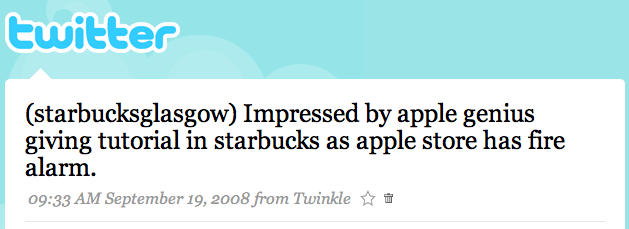
As mentioned in the previous post, mapme.at aims to make it as easy as possible for you to keep a complete location history. If you’re a regular twitter user then a really convenient way to do this is to send your location out whenever you twitter. By simply placing an address or the name of a favourite in brackets before your message you can tell twitter where you are. It’s unobtrusive, and it generally doesn’t hurt to tell your twitter friends whereabouts you are (especially if it makes them jealous!)
Getting mapme.at to read your twitter updates is very simple. You will need a twitter account so if you haven’t got one already then you’ll need to head over to twitter.com to sign up.
Once you’ve got a twitter account head over to your Location Sources page on mapme.at and scroll down the page until you see the Twitter logo. Enter your twitter username in the box provided but also take a look at the checkboxes and the different options for how you can update your location via twitter. By default all three should be checked allowing you four different ways to update your location via twitter, if you have a habit of sending messages with bracketed prefixes, or just don’t like how we geocode your messages then feel free to uncheck some of the options. Once you’re ready click “save” and we should begin reading your messages. Our twitterbot will only check every 5 minutes, but if you’ve sent multiple messages during that time we will notice and log them at the correct times in your history.
Twitter was actually used as an example in the first mapme.at blog post of something that you would like to geotag. When sending twitters myself I usually like to make sure I have already stored my location so that I can tie the location in at a later date, but this method allows you to tie the location right into the twitter itself. If you don’t like the idea of telling your friends where you are in every twitter, but you like the idea of the convenience of using twitter then a direct message should be right for you.
There are lots more ways to store your location so come back soon to find out more.
-
Maintaining your location with outside services: Fire Eagle
Since its conception mapme.at has always embraced the ability to use your location in as many ways as possible. FireEagle support was one of the first features and Twitter support followed soon afterwards. Being able to work with external services is highly important to mapme.at. The main aim of the site is to provide as many ways as possible to update your location - making it as easy as possible to have a complete location history. The more external sites we work with, the more ways you have to update your location.

Setting up Fire Eagle is pretty easy to do. You’ll want to start by heading over to the Fire Eagle website to sign up for an account. Once you’ve created your account on Fire Eagle you’ll need to come back to mapme.at and go to your “Location Sources” page (labelled “Sources” on your homepage). Scroll down until you see the fire eagle logo and you should see a link labelled “Click here to authorize your FireEagle account for use with mapme.at”. Click on that link and you’ll be taken to the Fire Eagle website and be asked whether you want to allow mapme.at to update and access your location.
We recommend that you allow mapme.at to both update and read your location, and that you give us access to your exact location. You can then use our controls to allow your contacts to have different levels of access. Whether you do this or not is up to you of course.
If you agree to let mapme.at access your location we will ping Fire Eagle around every 5 minutes and ask them for your location. If it’s changed since the last time we looked, we’ll store it in our database. Also every time you update your location on our site, we will let them know (if that’s what you have requested).
Having support for Fire Eagle gives access to a huge number of services for updating your location, take a look at the Fire Eagle Gallery to see which ones are useful for you. Not all services are compatible with Fire Eagle though, and some are unique to mapme.at. I’ll be posting a few more blog posts telling you about more of these methods over the next few days.


subscribe via RSS or via JSON Feed