Archive of posts with category 'General'
-
Sunsetting MapMe.At

It is with great sadness that I have to announce that I will be closing down the MapMe.At website in its entirety. From Friday 9th October 2020 you will no longer be able to access the site.
Why am I doing this now? The site has been creaky and old for many years now but I’ve left it running because I find it useful for myself. I even went to the effort of upgrading various parts of the software a year ago, but I stalled when it came to testing everything still worked and I never got around to releasing that.
A week ago I had a look to see if anyone is actually still using the site. As it turns out only a tiny number of people have actually logged locations for the entirety of this year. Even for my own purposes the only times I log locations directly with MapMe.At is when I’m at home, for everything else I use Swarm from Foursquare.
I truly feel sad doing this. I decided to take some screenshots of notable periods from the past 13 years that the site has been operating. Looking around the times that my two children were born, seeing the trace as I took my heavily pregnant wife to the hospital along the route with many, many speed bumps. Seeing what I posted to social media around those times, or just the normal life I was living before my son arrived, surprisingly, on his due date.
Personally I have a lot of memories tied in to the site and you may too, but unfortunately it is built on some really old technology and it really is time to turn it off.
Accessing your data
What does this mean for you? As mentioned above you will not be able to access the site from Friday the 9th October 2020. If you would like to take any screenshots of maps please do it before then. On request I will make available a dump of all of the locations that you have stored on MapMe.At. Please send an email to export@mapme.at to request this. To protect your data I will require that you respond to an email on the address that is registered with the site. If you need to change this email address you have 7 days to log in and do this! I will respond to emails on that address for 3 months after which I can no longer promise to help recover your data.
“How do I track my location now?”
For tracking check-ins your best bet really is just to go with Swarm. For tracking exercise activities then Strava and Runkeeper would be some of the obvious solutions. Really it does seem that you need to be tracking for a purpose and use an app related to that purpose. I know that the few users that continue to actively use MapMe.At are using it to track the travels of their yachts. For these people I’m not entirely sure what their best option would be but a good option appears to be the Adafruit IO APIs. I had hoped to write a blog post explaining how to do this, and may yet get around to it in the next few days.
If you have any other suggestions then let me know on Twitter and I’ll share them for everyone else to see.
“What about my WhereDial?”
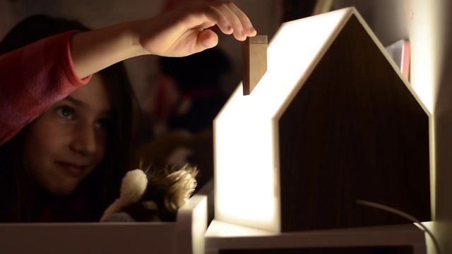
Well the WhereDial was a fun project! It was a really interesting experience to design and sell my own hardware. It was even featured in this fantastic book - Designing the Internet of Things (which was written by some good friends of mine!)
Unfortunately taking MapMe.At offline does mean that these devices will no longer work. As far as I know the only devices that have been activated recently are the ones in my house and in my Dad’s house. I really would like to have an option to keep them running, but MapMe.At isn’t it, and until I get time to think of something then unfortunately these will have to remain offline.
The WhereDial was designed as Open Source hardware so if someone has one and wants to get it working again they can find the WhereDial Arduino code on GitHub.
Thank You!
Thank you to the people who have supported me, who have given feedback, or have simply enjoyed using MapMe.At. I’m sorry that I can’t keep it going but I hope you enjoyed using it over the years!
- MapMe.At Founder - John McKerrell
-
Place Changes & Anti-duplication
We’ve recently put live a few changes around how places are stored in our database so we thought a blog post was in order to bring you up to date.
We now treat places that we’ve pulled in from Foursquare and Facebook the same as other places in our database. In the past you wouldn’t be able to favourite a location that came from Foursquare, but now you can! When we import a place from one of these services we have always looked in our database for any similar places and tried to match them up. Unfortunately if the name is entered slightly differently or the location has been recorded differently then it’s quite possible that we won’t be able to match it. This is why we’ve now added the ability for you to mark places as duplicates yourself.
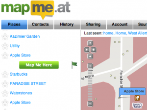 There’s two ways you can do this. If you’re accessing your main homepage through a regular browser then when you click on a location you will see the usual “Map Me Here” button but you will also see a new flag icon. If you tap on the flag we will confirm that you want to flag the duplicate and will then save that to the system. We review these reports regularly and will merge any duplicate places together. Don’t panic! If you’ve already checked into one or the other place we will update your old check-ins to point at the correct item.
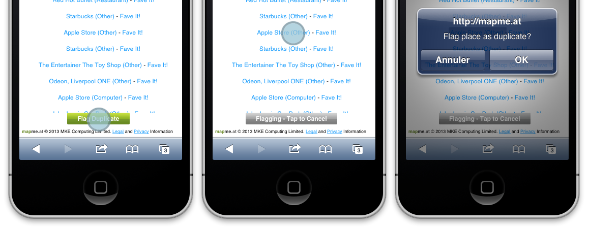
If you’re accessing our mobile site you will see a slightly different UI. Simply tap the button on the bottom of the screen, then tap on the place that is duplicated. If you tapped the button by accident just tap again and it’ll cancel.
We hope these changes will make the site easier to use and will help you to enjoy the site, and your WhereDials!
-
Bringing Internet of Things to Internet World 2013
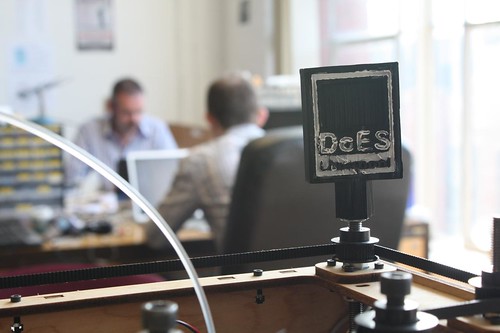
The following was originally posted on the DoES Liverpool blog. DoES Liverpool is a co-working space and community workshop in Liverpool, and is in fact where MapMe.At is based (our WhereDials are made on their laser cutter!) We thought you might like to hear about this so have, with permission, copied the blog post below:
You might think that “things” have always been connected to the internet. Computers, mobile phones, even printers have been connected for years. A lot of the current talk and investment in Internet of Things is large sensor networks and taking information from our environment. What we at DoES Liverpool like to think of when we talk about the Internet of Things is a whole lot more personal and unexpected. How about a bubble machine that blows bubbles when people mention you or your business on Twitter? Or perhaps a clock or dial that instead of showing time or statistics shows where someone is? These are just two of the ideas that members of the DoES Liverpool community will be bringing to Internet World this month.
But first, what is DoES Liverpool? We are many things. We are an online community of creative and often tech savvy people, of tech startups and “makers”. DoES Liverpool is also a physical space. It provides a co-working office space for members of the community to hot desk from or to take a permanent desk. There’s also a shared workshop with lots of equipment available for use; traditional tools such as soldering irons and band-saws to the more modern digital fabrication equipment like the laser cutter and 3D printers. We also hold regular events on many topics from specific programming languages like Python and Clojure through to more business focussed events like Lean Liverpool and Saturday Startup Club. We have a great community coming up with some wonderful ideas, and we’re looking forward to showing some of these to you at Internet World 2013.
Adrian McEwen has been putting things on the Internet for many years. He led the team who developed the first full web browser for a mobile phone, and his code (he’s slightly ashamed to admit) made it onto the Amstrad Emailer. He was recently described as an IoT pioneer by Kevin Ashton, the person who coined the term “Internet of Things” in the first place! Adrian will be bringing two of his IoT inventions to Internet World. Bubblino, the aforementioned twitter activated bubble blowing machine, was actually one of his first IoT projects but is well loved at conferences around the UK and has now been sold to various people in the UK and Europe. The Acker’s Bell was a more recent commision to provide Liverpool Startup ScraperWiki with a bell that would chime each time they made a sale. The mounting for the bell was designed and laser cut in DoES Liverpool with Adrian developing the software and electronics. Usually living in ScraperWiki’s office in Liverpool the Acker’s Bell will be visiting London for you to see at Internet World 2013
With another DoES Liverpool co-founder, Hakim Cassimally, Adrian has spent the last year writing the definitive IoT book - Designing for the Internet of Things. Both Adrian and Hakim will be available to discuss their book and IoT in general, and of course you can pre-order the book on Amazon!
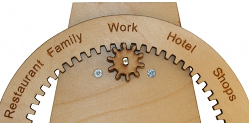
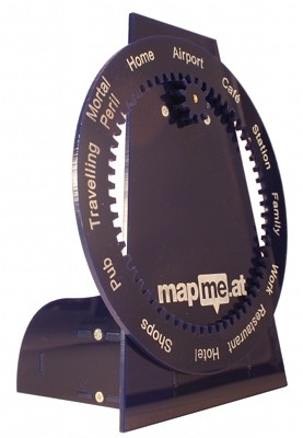
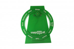
Inspired by the clock owned by the Weasley family in the Harry Potter books, the WhereDial provides a delightful way to make a personal connection with a family member or friend. The WhereDial is made from laser cut plywood or colourful plastic and features a list of location categories around the dial. Through the cloud based location aggregator - MapMe.At - the WhereDial can retrieve a person’s location from FourSquare, Google Latitude and a variety of other services. It then rotates the dial to show where the person is. It’s a great device for people who are less comfortable using mobile phones and computers but is also a really handy glanceable object that fits nicely on the desk of a technophile too. The WhereDial was designed and is built in Liverpool by John McKerrell, also a co-founder of DoES Liverpool.
Perhaps saving the best for last, the final headline item that we’ll be bringing to Internet World 2013 is the Good Night Lamp. Darling of CES and Gadget Show Live, these lamps have a superstar team behind them. They are the brainchild of Alexandra Deshamps-Sonsino, previously a co-founder of smart product design studio Tinker London and the organiser of the monthly Internet of Things meetups in London. She launched the Good Night Lamp as a startup a year ago by committing to taking a booth at CES; 10 months of development later and with a live Kickstarter campaign garnering much publicity she took CES by storm. Her team includes our own Adrian McEwen as CTO; John Nussey as Head of Products and interior designer & architect Konstantinos Chalaris as Lead Designer.
We really hope you will enjoy our exhibition and go away inspired, potentially with some ideas for an IoT product of your own! DoES Liverpool is all about inspiring people to start interesting businesses and while our focus is in Liverpool, we know that IoT is going to take off around the world!
-
Latitude API, Mobile Web and Snappy Places
We’ve recently released some new changes which will provide more tracking options for everyone but may be of particular note to those of you with a WhereDial to update.
 The first thing to mention is our improved Latitude support. We are now plugging directly into the official Google Latitude API, rather than using their “Badge” API. This means that you can link your latitude account to MapMe.At without having to make your location public to anyone else. Google Latitude is a great way to track your location passively. Running in the background on Android and iPhone devices, Latitude will keep an eye on your location and let MapMe.At know when it changes. It does this intelligently too, using your device’s lower power systems to detect when the location has changed rather than running the GPS continuously.
With the Google Latitude API support we’ve also introduced some new attributes into logged locations: altitude, horizontal accuracy and vertical accuracy. We have also added functionality that means if someone provides us with a new location for you which has no place information but is very close to your previous check-in which did have a place attached, we will re-use that place information. There’s more technical information below but these changes should help to give you a cleaner trace with fewer instances of you bouncing between a place and an anonymous location as different services provide a location for you.
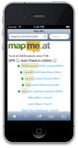 The final thing we wanted to mention is our mobile site, https://mapme.at/me/mobile. We don’t talk about it very much but this has been around for a while now and gives you a handy way to check-in to places near to where you last checked in or, if your device can provide a location, near to where you are now. Your nearby favourite places will appear at the top with other places appearing further down, closest first. It will even check you in automatically. If you select the second checkbox then once your device gets a location with an accuracy of less than 50 metres it will check you in. As ever MapMe.At will try to find a favourite place nearby or just store your anonymous location if necessary. If you leave this running while travelling it’s a great way to get a continuous trace with a little more accuracy than Google Latitude will provide.
We hope you enjoy these changes, let us know via twitter or Get Satisfaction if you have any problems. Read on for some more technical details.
Extra Technical Details
Before we made these changes we often found that our history could be “broken up” by locations provided by multiple services. For instance checking into Foursquare with a “shout” can result in a geo-tagged tweet. This could mean that your history would show a check-in to your favourite art gallery followed straight away by an anonymous location being logged moments later as the tweet would not be linked to the Foursquare check-in. The new changes mean that your tweet’s location would be detected as close enough to your previous check-in to be at the same location and the place information would be copied across. Note that this will only occur for a new check in and be compared to what MapMe.At thinks your current location is. Unfortunately right now it would be too intensive to check with historical check-ins.
We’re using the new horizontal accuracy information to define how close is close enough. Some services will provide locations with less accuracy, e.g. 5000m. This may seem useless however if it’s your first location in a new country then you will probably want to log the visit to a new country and be less concerned about the inaccuracy of the location. However if you haven’t really moved you obviously don’t want MapMe.At to think you are no longer at home, for instance, just because it has received an inaccurate check-in. If the service that we get the location from gives us accuracy information then we will use this to define how close your previous check-in needs to be. We’re only doing this with Google Latitude right now but we will extend it to other services in the future.
-
We Have a New Wiki
To try to improve the management, and quantity, of documentation on the site we now have a wiki! You can find it at https://mapme.at/wiki
You will need to log into MapMe.At to access the wiki but once in you will be able to view, and edit, all the documentation that we have.
We’ve copied across all the content that was previously on this blog and supplemented it with some new information. There’s still plenty more that we need and we’d love your help. What mobile apps do you use? What ways have you found to show your location? Have you built a delightful little hardware device for showing your current location? ;-)
We can’t wait to see what updates you make, remember you’re welcome to edit any pages on the site so if you come across a mistake or typo in a page, just fix it! Your name and MapMe.At username is attached to all your edits so do please keep it clean :-)
As a little addendum, have you seen that we’ve been nominated for the Postscapes Internet of Things Award 2012, in the Connected Home category? Take a look and, if you think we deserve it, vote for us!
-
WhereDial Now Available to Buy!
 We’re so glad to announce that we are ready to start shipping WhereDials!
If you haven’t come across the WhereDial yet it’s a cute “Internet of Things” device that you can use to connect friends and family to your daily life, or to keep yourself connected with your loved ones. You simply power it on and plug it into an internet connection. It then rotates the dial to show the location of the person at the top. Whether you’re in work, at home or in the pub, the WhereDial has you covered.
If you buy a WhereDial now we’re going to try our best to get it to you by Christmas so you will receive a dial with a standard set of locations with the option to buy customised dials coming in the new year. It’s still early days for the WhereDial project. Now that we’re happy with the hardware we’re putting our focus back on the MapMe.At website that supports it. We’re planning to add full support for Google Latitude and Facebook, and will be improving support for Foursquare and Twitter.
For more information take a look at the WhereDial page or to buy one head over to the WhereDial shop!
About Pre-orders
 Last year we invited you to order a WhereDial and started collecting details, including name and address. We were originally intending to use this to send out invoices but felt that as a year had gone by this would not be appropriate. It also wouldn’t give you much option to pick a colour and material that you liked. As such we will be taking no further action on those “orders”. We did not take any money previously and so would ask that if you did order before and still want to buy a WhereDial then please head over to the shop to complete a purchase there.
-
It's Good to Share
We’re glad to be able to announce a new feature on the site (yes, the first real new feature in a while!) - Sharing Codes.
The idea behind sharing codes is that a lot of people will want to share their location with friends and relatives who may not want to sign up to mapme.at, we recognise that and wanted to give you a way to share your location with some people while keeping your default public settings to something more restricted.
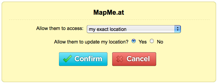
To get started log into mapme.at and click on the new “Sharing” tab at the top. You’ll be taken to a page that should look familiar, it shows you your current group accuracy settings but below you’ll also see the new “Sharing Codes” section:
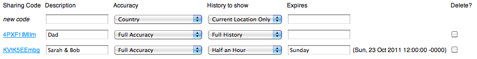
It’s quite a big form but don’t worry, it’s quite simple really! The only thing you absolutely must enter is a description; this gives you a way of tracking what sharing codes you’ve created, whether it’s one for your parents, friends or perhaps even an employer, simply enter a description and save and you’ll get a new sharing code. We recommend that you create a new code for each person or purpose, that way if someone finds out one of your codes you can easily delete it and create a new one. The other fields let you specify how long the code is active for and the accuracy and amount of history to show, here’s a full breakdown off the sharing codes:
Sharing Code
This is the actual sharing code you'll be giving out. Most people will simply want a link to the history page so that's the link we give you, the sharing code can also be used with the API, more about that later.Description
A short description so that you remember who you gave the code to.Accuracy
The level of accuracy you want to show for this code. Standard options from "Country" to "Full Accuracy", you can also set "No access" if you want to disable a code for a time.History to show
Perhaps you're happy for someone to see your current location but you don't want them to be able to see everywhere you've ever been. This setting allows you to restrict how much of your history they can see.Expires
If you want the sharing code to expire after a while enter a date and time in this setting. Various plain text times are accepted, once the code has been saved we'll show you the accurate time we've determined. We won't recalculate this until you edit the text. If you don't enter anything for this then the sharing code will be active indefinitely.Delete?
Want to delete a sharing code? Check this box and click "Save" below.Remember that you must only share these codes with people you really want to see your location. If anyone else finds out a sharing code they will be able to see your location.
As mentioned above the sharing codes can be used with the API, simply pass
sharing_code=[SHARINGCODE]and the API will your return your history to the level of accuracy you have specified. This is great for simpler applications where full OAuth access would be overkill. You can also use the sharing code with the export API but remember that if you put a sharing code on a webpage, even in the HTML, others will be able to read it and read your history, perhaps to a greater level of detail than you intended.So play with the codes and let your family and friends find out where you are! As this is pretty fresh code there may be bugs so if you spot anything, let us know!
-
State of the Map 2010
This past weekend saw the annual OpenStreetMap “State of the Map” conference arrive in Girona, Spain. I attended for the fourth year running and was glad to be given the opportunity to talk about mapme.at, what it is and how it uses OpenStreetMap data.
I started by giving a brief overview of the site, the functionality offered and how we integrate with many other services. I then went on to describe mapme.at as a “Social Location Experimentation Platform”. My idea behind this concept is that mapme.at gives people many ways to experiment with their location. On the one hand it allows regular users to experiment by trying out various services that become available. As an example, someone might decide to try Google Latitude out, perhaps as they’ve just got a new android phone. After a few weeks this person might decide that latitude isn’t offering what they want, perhaps they prefer the badges and mayorships of Foursquare. If they’ve signed up to mapme.at they can store all of their locations in our database where they will be available to the user to download or use in the future. In this way users can experiment without having to think “there’s no point trying this service out as I’ll just stop using it after a few weeks”.
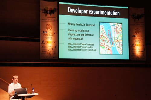
The other type of experimentation is developers experimentation. Developers can use our API to experiment and produce all sorts of great apps. I mentioned the ferry trackers as an interesting example of putting data in, and then the “Weasley” clock as a fun example of pulling data out.
I also discussed some new functionality that we’re hoping to launch soon. Currently though we use OpenStreetMap as our canonical source of place data, there’s actually three sources that places might come from. If you’ve been using OpenStreetMap since before we launched the places functionality you may have added favourites for places you went to. Many of these favourites are public places that are now covered by the OpenStreetMap places. Part of the new functionality will allow you to merge your old favourites with the OpenStreetMap places meaning you’ll have a single set of logs all attached to the same place. If you’re using Foursquare you may have noticed that we do try to match their “venues” onto our places. Sometimes this isn’t possible though and if you’re using both mapme.at and Foursquare to check in you’ll sometimes find you’re logged at two separate places. The second part of the new functionality will allow you to manually match Foursquare venues onto our places so again you end up with all your logs attached to a single place. The result of this piece of functionality should be a big database of mappings between Foursquare venue IDs and mapme.at place IDs, and by extension OpenStreetMap IDs. We fully intend to release this data when it becomes available and we think this will be a good useful dataset for many people.
How I built a location-based social app
View more presentations from johnmckerrell.
If the talk sounds interesting you can find my slides on slideshare or see them above. I believe all the talks were recorded too so videos should go live eventually. I’ll finish off by thanking the people who organised the conference. It really is one of the best conferences covering location and all things geo and they really did a good job of pulling everything together. The only thing left is to ask where will State of the Map 2011 be?!
-
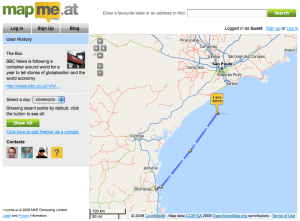
O'Reilly Where 2.0 2010
This week we’ve been at the Where 2.0 conference in San Jose, California. We submitted a talk and were fortunate enough to have it accepted. The talk was “Why I Track My Location and You Should Too” and involved John McKerrell, the founder of mapme.at, talking about his experiences of tracking his location and some insights he’s found over the years. We’ve put the slides for this presentation live on slideshare in case you want to take a look.
As part of this presentation we got in touch with the great people at ITO World. They’ve created some great graphics and visualisations in the past such as the OpenStreetMap Year of Edits image and video, and the OpenStreetMap response to Haiti earthquake video. Knowing that they can create some amazing work we asked them “What could you do with three years of personal location data?” In just a few weeks they came up with some really impressive visualisations.
All trips taken in the past 3 years from John McKerrell on Vimeo.
That image shows every single trip taken by John and stored in the mapme.at database. It shows all trips visible at once which is great on a global view but perhaps you’d like to see something a bit more close up, here’s every trip in London with all days shown at the same time:
All my travels in London run at once. from John McKerrell on Vimeo.
There’s more videos available, take a look at the slides on slideshare or on vimeo to see them.
We’ll be at the WhereCamp in Google’s offices in Mountain View this weekend. If you’re there say “Hi”, we’d love to discuss location tracking and visualisation with you.
-
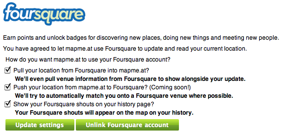
Foursquare Support Now Available
We’re happy to announce that we now have support for linking your account to Foursquare. If you haven’t tried it yet, Foursquare offers points, badges and more when you “check in” to locations.

We’ve still got some things to finish up to complete the support but right now you can go to your Sources page and link your account to Foursquare there. You have three options for how we’ll work with your Foursquare account. You can choose to let us pull your location from Foursquare which means that all your check ins get pulled into MapMe.At. Where possible we’ll match the Foursquare Venues onto our own places but where that’s not possible we’ll create an entry on our site to allow you to show people exactly where you are. You can also choose to make your “shouts” visible so people can see what you were doing when you checked in.
We will be adding support to push your locations from MapMe.At back into Foursquare soon so if that sounds good, just check the box when you link your account and we’ll start pushing locations over as soon as that’s ready. Again when we push locations into Foursquare we’ll try to match our places onto theirs where possible.
If you have any problems let us know over on Get Satisfaction or by mentioning our twitter account.
-
Place based locating
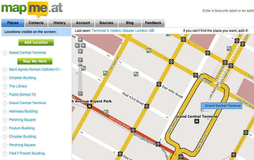
You may have noticed that we recently launched some new functionality on the site. In the past when you wanted to map yourself you had, essentially, two options for describing that place. If you had some way of finding out the latitude and longitude for where you were you could give us that, or you could create a “favourite” which would give you a nice handy label to use instead and let you give a small description of where you were. We thought the favourites were a good way to attach something small and memorable to your location and make it really easy to map yourself wherever you are in the world by using Twitter, web or even DNS. If you didn’t have a favourite created in advance though it could be quite difficult to log your location if you didn’t have a GPS device or something similar though. We’ve now taken a big step towards making it easier to map yourself, whether you’re in the office, in the pub or in any of millions of places around the world by introducing “Place based” locating to mapme.at.

So, what does this mean? On Wednesday we pushed out an update to the site that gives you access to a huge database of places of interest. If you go to your homepage you’ll now see not just your favourites showing up but also other places from our database. These places will be listed on the left hand side under your favourites. They’re also displayed on the map as subtle little dots. Click on one of the places, either on the map or the text on the left to open up the place and map yourself there. You can also mark any of these places as a favourite by clicking on the star in the left hand side, optionally giving it a label, and clicking save.
 Don’t worry about your existing favourites, these have all been converted to private “places” and we’ve marked them as your favourites.
By default your homepage will centre on the last place that you mapped yourself to but if you’ve moved on from there you can either pan the map to your new location or use the search box on the top right. Remember that when searching more information is good, rather than just using “Market Street” something like “Market Street, San Francisco” is always going to give you better results.
If you have a browser that supports geolocation such as Firefox 3.6 or if you have Google Gears installed you should see a link marked “Find Me!” at the top right. If you click on that we’ll ask your browser where you are, it should ask for your permission and then we’ll move the map to where you are and show you some places nearby.

You might notice we’ve added a description of your current location to the top left of the map. This will remind you of where we think you are but you can also click on it if you want to bring the map back to your current location.
We source these places from OpenStreetMap, using the fine APIs provided by CloudMade. This gives us a constantly growing database of millions of places across the globe. Even so, nobody’s database is perfect so you might find that the place you’re at isn’t available. If this happens you can easily create a new place by clicking on the “Add Location” link on your homepage.
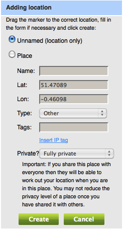 If you mark the location as “Private” then nobody else will be able to map themselves there - you might like to use this for your home. If you share the location with your contacts then any contact that has full accuracy to view your location will be able to map themselves there. You can also share places with everyone, and if you do this we’ll even push these back into the OpenStreetMap database so everyone benefits!
With all this going on we’ve still found time to create a mobile tailored web page which is great to use on iPhone and Android devices, and should work fine on anything with a modern mobile browser. Go to http://mapme.at/me/mobile and you’ll be shown a description of your current location and a list of nearby places. If you click on the GPS link it will look-up your location from your phone’s GPS or location services (assuming your phone supports this) and update the nearby places. If you click the checkbox marked “Auto” then we will monitor your position and update the places as you move. When you see the correct place in the list just click on it to map yourself there. If you click the second checkbox we will even log your location continuously if we have a location accuracy of less than 50m. You can still map yourself at your favourite locations using labels like “mapme.at/home” and do “on the fly” searching using something like mapme.at/Constitution Hill, London - this is great for mobiles that don’t support JavaScript
If you’re using our API you’ll find that the methods relating to “favourites” will no longer work. Favourites as they used to work no longer exist on mapme.at. From now on everything will be about places. API methods are in place for accessing places right now though and can be used by simply replacing “favourite” with “place” in the URL.
So we really hope you enjoy the new functionality and find it useful. There’s more to come but please feed back to us any comments you have!
-
Cycling 800 miles to Copenhagen
The problem with holding an international conference on climate change is the huge amounts of carbon dioxide that will be generated by all the attendees getting to the event. In the case of this week’s conference that means people crossing the globe to get to Copenhagen. One person from the UK decided there had to be a better way and decided to cycle the 800 miles from Birmingham to Copenhagen!
Darran Martin is part of the UK Youth Delegation to Copenhagan (UKYCC), 23 people from across the UK who are attending the summit trying to urge negotiators and World leaders to push for a deal which guarantees our futures.
If you take a look at the video linked below you might notice that Darran took with him two GPS devices. Our friends at Cloudmade donated a SPOT Satellite GPS Messenger and we at mapme.at gave him a Holux GPSlim 236 device working together with a Sony Ericsson k750i to use. As is usual with technology there was still a few hitches so we don’t have a very detailed trace but you can take a look at Darran’s History over the last week and get an idea for just how far he had to travel.
Getting 23 people from the UK to Copenhagen isn’t cheap, getting a group from Kenya to Copenhagen is even worse. The UKYCC are accepting donations to help them cover the cost of both these trips so any donations will be gratefully received.
Take a look at the site for a fun video made by Darran on his trip across Europe and then don’t forget to donate too!
-
Interesting Location/Clock Mashup
Update 16/12/2011: You can now buy one of these, go here for more information about WhereDial!
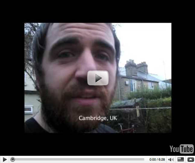
John McKerrell has blogged about a hardware hacking project he recently created mashing his location up with an old fashioned clock using an Arduino circuit board. The “Harry Potter” style Weasley clock has the names of favourites shown on the face of the clock and the hands of the clock move to point at his current location. Take a look at the video below or head over to his blog for more information.
-
Google Latitude now supported
Google Latitude is one of the increasing number of “location based social networks”. Google’s service is currently very simple, you can update your location via a mobile or on the web, you can then share your location with specific friends either at a city level or at full accuracy. They recently added a “Public Location Badge” that you can add to your blog to show your location to everybody that visits (we launched a similar service earlier today). Along with this they’ve also added a JSON feed that developers can use to pull your location into third party services, which is great news for us.
To use Google Latitude with mapme.at you’ll need to start by signing up for Latitude and enabling the Public Location Badge. On the page for the badge you should see a link entitled “Public JSON Feed”. Copy that address and then head over to your Location Sources page on mapme.at, scroll down the page until you find the Google Latitude section, enter the address in the box and you’re all set! Within a few minutes we’ll start requesting your location from Latitude.
Unfortunately, for mapme.at to be able to pull your exact location from Google Latitude and build up an accurate history, you will have to enable full public access to your location on Google Latitude (note that you can still hide your location in the standard ways on mapme.at). Obviously this is not ideal but until Google enable an authentication system or some better way of sharing your Latitude location, it’s all that we can offer to you.
One of the really good things about Google Latitude is that their mobile software already runs on so many phones. Already running on most Symbian S60 devices, Windows Mobile 5.0, colour BlackBerry devices and more, it’s quite likely that you’ll be able to run the software on your phone. The obvious omission of course is the iPhone but we already support InstaMapper’s GPS Tracker application and Thom Shannon’s novel email-base location tracking method for iPhone users so that shouldn’t be much of an issue.
-
Show your location on your blog or other websites
So we’ve been working on the history page to try to make it a good way to see where you’ve been and to share your location history with friends. There’s more improvements to come but you might be thinking “yes, the history page is good, but I want to be able to show my location history on my own website.” We’ve now got a couple of ways to let you do this. The first that we’ll talk about is a plugin for the Drupal content management system, the second is something you can use with any website.
 Dan Karran has written an integration module for the Activity Stream module of Drupal. If you take a look at the blog post you should be able to get this module installed and tell people where you are.
The other method to share your location is with the new “Export” feature of our API. To use this you just need to add an iframe to your page linking through to the new page with a URL such as
https://mapme.at/api/export.html?usernames=thebox. You can pass one or more usernames as you see fit (separated by commas), you can also pass arguments to specify the time and date that you want to show locations from, using similar arguments to the API ‘where’ method. Here’s a page showing history for “The Box” from the BBC over the past 3 months:https://mapme.at/api/export.html?usernames=thebox&mode;=since&since;=3%20months%20agoIf you only pass usernames in then the page will show the current location of the user and as already mentioned you can also link to multiple users. Here’s the map showing the current location of the ferries on the River Mersey in Liverpool, GB:
https://mapme.at/api/export.html?usernames=royaldaffodil,royaliris,snowdropThe export method uses the same security precautions as the rest of the site so if you want to use it to show your location to members of the public you may need to change your location sharing preferences, as always only expose as much information as you feel comfortable with. There’s more information about this on the documentation page for the export method so take a look there and then try it out!
-
Add a user profile to put life into your history page
We’re glad to announce that we’ve just released a code change which allows you to enter a user profile onto mapme.at. Go to the Account page and you can add a short description of yourself, a link to your website and even upload a picture of yourself. We recommend doing this as it will add real life to your history page. We’ve even made it easy for you by adding the ability to pull your existing profile information across from twitter.
At the same time we’ve also modified the history page so that you can see the list of contacts for the person who’s history you’re looking at. This should make it really easy for you to build up your list of contacts by seeing who your friends are in contact with and adding them yourself.
If you’re updating your profile please remember that everything you put in there will be visible to anyone, even people who have not signed up to mapme.at or made contact with you, only enter information you’re happy for everyone to see.
 So head over to your account page now and get uploading or importing. Let’s banish the orange question marks as soon as possible!
 -
The Future of Online Location Tracking?
You’ve probably noticed by now that mapme.at has had a bit of a makeover recently. This was all done as part of a changeover to using mapping services from CloudMade, a London and San Francisco based company aiming to bring the power of crowd sourced data from OpenStreetMap to more people. CloudMade were so impressed with our integration of their services that they asked us to speak at their recent developer launch events. We decided to take that opportunity to make a few announcements that we hope you’ll be excited to read about below.

Great New Look and Feel
For our new design we enlisted the help of the great team at Cogniance. They worked with us to provide a new logo and overall look and feel. They also gave us some ideas for improvements to the user experience; many of these have been implemented already but some are still on the list to be completed soon. We’re really happy about how the new look has turned out, the bright colours really inject life into the site and the fact that we’ve been able to tie these in with the map is just amazing, more on that in a moment…
CloudMade Integration
So far we’re taking advantage of just a few of the great services that CloudMade provide. In the previous section I mentioned the fact that we have been able to link our colourscheme into the colours used in the map. This is possible due to the groundbreaking new “Style Editor” tool from CloudMade. With this you can edit the styles used in the map to your heart’s content. Our map style was based on one that CloudMade call “The Original”, this looks really nice and only required us to spend a short time playing with the style editor to get it coordinating with our colours.
We’re also using the Geocoding services that CloudMade provide. Geocoding is the process by which a computer takes a written address, such as “10 Downing Street, London” and converts it to a latitude and longitude. We use this service on the homepage to make it easier for you to find your current location and create favourites, and with the twitter integration when you’re out and about. We’re really happy with the results we’re seeing from this service and we know that CloudMade are working hard to make it even better.
By using the unique OpenStreetMap dataset CloudMade are able to provide some really good services giving us access to the data at a very low level. We’ve got some ideas for how we can more closely integrate them into the services we provide on mapme.at and you should see these developing over the coming months.
You may notice that OpenStreetMap and therefore CloudMade do not have street level coverage worldwide. It’s actually the case that no mapping provider currently has coverage throughout the world and, similar in some ways to those providers, OpenStreetMap has some areas with better coverage than others. The one big difference is that if you find that the coverage around the locations that you visit often is lacking, you can get involved with improving this. We at mapme.at are big fans of the OpenStreetMap project and have been contributing for a number of years. We whole-heartedly recommend that you get involved, you might want to try signing up to their mailing lists or just take a look through their “wiki” to find out how to get involved.
New OAuth Developer API
At mapme.at we’ve always tried to make it as easy as possible for you to update your location. We already provide integration with Twitter and with FireEagle. You can update your location through the web, via email or even using DNS. So far though all of these integrations have required us to do most of the work on our side, meaning that you couldn’t use a new method, such as a new mobile app, until we had done some work integrating it. We are now opening up an API (Application Programming Interface) so that any developer can sign up and integrate their application with the mapme.at site.
An API is essentially a set of instructions and methods that we give to developers that tell them how to access our website and update the data that we store here. Obviously it wouldn’t be very good if just anybody could access all the data we store, or change everybody’s data so to stop that we use authentication. We’ve decided to use the OAuth authentication scheme to make sure that we take the best possible care with your data, while allowing you to make the most of third party services that will enrich your experience of mapme.at. OAuth allows you to give permission to a third party service to access or update your data on mapme.at without you needing to give them your username and password. This means that if at some point in the future you decide that you don’t want this service having access to your data, you can simply revoke that access from our website. If, for instance, you gave a mobile app on your phone access to your data, and then lost your phone, you could still revoke the access even though you can’t use your phone.
If you’re interested in trying this out then you can find the documentation about our API here. We’re just starting out with this so we’re declaring that our API is currently in “beta” mode. This means that we’re still working on it and the way it works is likely to change in the future, we’ll try to keep you informed in advance of any major changes though. We’ll also be working to extend the documentation further to cover more aspects of the API.
one more thing… iPhone!
The final thing that we mentioned in the talk at CloudMade is that we’re currently working on a native iPhone app to really simplify use of the mapme.at services on the iPhone. It will use our custom map tiles so will look really good, and will allow you to update your location, see which of your contacts are nearby and continuously track your location. It’s still going to be a few more weeks before it’s ready but as soon as it is, we’ll let you know!
As you can tell there’s been a lot happening recently with the mapme.at site. The development doesn’t end here though so we’ll be continuing to add new features over the coming months. We’ll also be extending the documentation not just for the new developer API but also the documentation for the site in general. Finally we’ll try to keep you more in the loop by keeping this blog active, so sign up with your favourite RSS reader to make sure you hear it about it straight away!
-
Tracking "The Box" around the world
If you’re a regular reader of the BBC News site you may have seen their recent stories about “The Box” - an experiment that the BBC are running to track the locations visited by a single shipping container over the course of a year. There are various pages on their site giving more information including the story that introduced The Box, a map of locations travelled to by The Box and a whole section of further information.

I find this a very interesting story to follow. Though The Box travels quite slowly, and therefore is not something to follow on a minute-by-minute basis, it will end up travelling long distances and should create a thorough map of the busiest shipping lanes and ports throughout the world. As such it’s certainly something I will be keeping an eye on. I thought it might be useful to have an Atom feed with GeoRSS to make it possible to follow the path of The Box without having to remember to check the site. I was also quite interested in creating a user account for The Box, pulling the location of it into mapme.at and allowing users to follow the location on this site. Fortunately I can now announce that both these things are now possible.
I’ve put together a basic script that pulls down the location of The Box every half hour and places this into the mapme.at database. The username is “thebox” so you can see its current location at https://mapme.at/where/thebox. I’ve set the permissions on the account so that anyone and everyone can view its location, but if you add it as a contact then it will show up on your homepage if you ever happen to be nearby.
You can also follow the path of The Box by using a new feature of the site. The following URL will return an Atom feed for the user “thebox” for all logged locations since midday “yesterday”:
https://mapme.at/api/where.atom?username=thebox&since=yesterday&mode=since
This next URL will give all logged locations since The Box was launched on the 8th September:
https://mapme.at/api/where.atom?username=thebox&since=2008-09-08+00:00:00&mode=since
If you use this in a standard RSS reader such as Google Reader or Thunderbird you’ll find an entry for each location that the box has been to, a small map of the area and a link to the history page for that day. If you load the RSS file into something that can read GeoRSS you’ll see a map highlighting all of the places it’s been to, for instance here’s the link loaded into Google Maps. Loading it in a standard RSS reader is a good way to be kept up to date about when The Box moves without having to look yourself.
As you might have guessed, you can also use this URL to track your contacts, though at the moment you will only be able to do this if their location is open to the public. More features along these lines should be coming soon!
-
Maintaining your location with outside services: Twitter

As mentioned in the previous post, mapme.at aims to make it as easy as possible for you to keep a complete location history. If you’re a regular twitter user then a really convenient way to do this is to send your location out whenever you twitter. By simply placing an address or the name of a favourite in brackets before your message you can tell twitter where you are. It’s unobtrusive, and it generally doesn’t hurt to tell your twitter friends whereabouts you are (especially if it makes them jealous!)
Getting mapme.at to read your twitter updates is very simple. You will need a twitter account so if you haven’t got one already then you’ll need to head over to twitter.com to sign up.
Once you’ve got a twitter account head over to your Location Sources page on mapme.at and scroll down the page until you see the Twitter logo. Enter your twitter username in the box provided but also take a look at the checkboxes and the different options for how you can update your location via twitter. By default all three should be checked allowing you four different ways to update your location via twitter, if you have a habit of sending messages with bracketed prefixes, or just don’t like how we geocode your messages then feel free to uncheck some of the options. Once you’re ready click “save” and we should begin reading your messages. Our twitterbot will only check every 5 minutes, but if you’ve sent multiple messages during that time we will notice and log them at the correct times in your history.
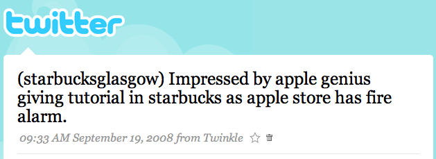
Twitter was actually used as an example in the first mapme.at blog post of something that you would like to geotag. When sending twitters myself I usually like to make sure I have already stored my location so that I can tie the location in at a later date, but this method allows you to tie the location right into the twitter itself. If you don’t like the idea of telling your friends where you are in every twitter, but you like the idea of the convenience of using twitter then a direct message should be right for you.
There are lots more ways to store your location so come back soon to find out more.
-
Maintaining your location with outside services: Fire Eagle
Since its conception mapme.at has always embraced the ability to use your location in as many ways as possible. FireEagle support was one of the first features and Twitter support followed soon afterwards. Being able to work with external services is highly important to mapme.at. The main aim of the site is to provide as many ways as possible to update your location - making it as easy as possible to have a complete location history. The more external sites we work with, the more ways you have to update your location.

Setting up Fire Eagle is pretty easy to do. You’ll want to start by heading over to the Fire Eagle website to sign up for an account. Once you’ve created your account on Fire Eagle you’ll need to come back to mapme.at and go to your “Location Sources” page (labelled “Sources” on your homepage). Scroll down until you see the fire eagle logo and you should see a link labelled “Click here to authorize your FireEagle account for use with mapme.at”. Click on that link and you’ll be taken to the Fire Eagle website and be asked whether you want to allow mapme.at to update and access your location.
We recommend that you allow mapme.at to both update and read your location, and that you give us access to your exact location. You can then use our controls to allow your contacts to have different levels of access. Whether you do this or not is up to you of course.
If you agree to let mapme.at access your location we will ping Fire Eagle around every 5 minutes and ask them for your location. If it’s changed since the last time we looked, we’ll store it in our database. Also every time you update your location on our site, we will let them know (if that’s what you have requested).
Having support for Fire Eagle gives access to a huge number of services for updating your location, take a look at the Fire Eagle Gallery to see which ones are useful for you. Not all services are compatible with Fire Eagle though, and some are unique to mapme.at. I’ll be posting a few more blog posts telling you about more of these methods over the next few days.
-
How to make friends and track people
Now that you’ve hopefully got your account setup and have been tracking your trips between home and work, you might want to share this information with people you know. mapme.at gives you a couple of ways to expose your location to friends, family and the world at large.
The main way to expose your location to people within mapme.at is to create a list of contacts that are also using the site. Currently there is no search mechanism for finding people so you will need to find out their username through some other means - twitter, email and instant messenger are great ways for communicating this information with people (ok, maybe a search function would be good, coming soon…)
Once you have the username of someone you want to share with you’ll need to login to mapme.at and look at the contacts tab on your homepage. You should see a simple form with a box for the username and then a few choices for how you want to identify the person. Now for the important bit:
MAKING SOMEONE A CONTACT MAY ALLOW THEM TO SEE WHERE YOU ARE
This is very important to realise. mapme.at is all about sharing your location. This is a great thing and has many uses, but you may not want everyone to be able to find out your accurate location. Please think very carefully about who you share your location with. We’ve given you three options to allow you to filter people, if you’ve used flickr before you will have seen something similar. Some photos may be just for friends, some for family and some for everybody to see. In the same way mapme.at allows you to give friends, family, other contacts and the world at large access to see your location to different degrees. Think carefully before deciding which group you want to put someone into. Other contacts can’t see what group you’ve put them into so hopefully they won’t be offended (though they will be able to tell what accuracy level they can view your location at).
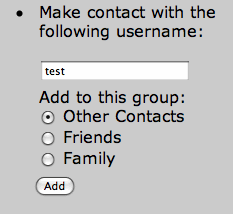 Once you’ve decided what group you want to put someone in you need to enter their username and select the correct option. Click on the button and you’ll now be in contact with that person. They will be sent an email to inform them of the fact and be given the option to get in contact with you too. Be aware that at this point you have only given the other person the ability to see your location, you will not be able to see their location until they make contact with you. You will also need to set your permission levels, read on to find out more about that.
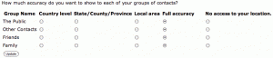
When you sign up to mapme.at initially, the default settings don’t allow anyone to see your location. To alter these settings and share your location you’ll need to go to the contacts management page, here you’ll find entries for each of the groups that you can assign contacts to, and one for the general public, and settings that modify the amount of access you’re giving that group. Modify the settings to suit you and click “Update” and you’re ready to share your location with people. Be aware that if you modify these settings they apply to previous locations that have been stored. If you open your privacy settings for a specific trip, people may still be able to look into your history to find places you’ve been previously. In the future we’ll be looking at improving this mechanism but for now be aware of what you’re doing when you make changes.
Now you should be all ready with a few contacts and be able to see where they are. Notice that contacts show up on the map on your user homepage so that you can see who is around you at any time, you can also drag the map around and it will update to show contacts in the area you’re looking at. If you want to see where someone has been previously you can take a look at their history page, you’ll find this at mapme.at/where/
- or simply click on their name in the contacts section on your homepage. If you've set your privacy level so that members of the public can see your location then they'll also be able to use that URL to track where you are. This blog post may come across as quite serious, all this stuff about “be aware of what you’re doing” may seem over the top. At mapme.at we’re really concerned about privacy and want to make sure we don’t confuse you and cause mistakes to happen. As mentioned above we’ll also be adding more features in the future to give you finer control over what you share and what you don’t. Keep an eye on this blog for future updates.
-
Creating a favourite and "mapping" yourself there
The way in which you’re most likely to map your location while using mapme.at is to use favourites that you’ve created in the past. Favourites allow you to save a location into the mapme.at database, assign some tags and a description and then use it multiple times in the future. This method makes it easier to group together your visits to a single location in a way that would not be as easy if each visit was simply stored as a latitude and longitude. The favourite also gives you a way to inform the world some of the meaning surrounding the location you’re currently in. The favourite label, description and tags are all publicly visible, even if a person only has country-specific rights to see your location.
While location is very important and helps to convey meaning, it often isn’t enough on its own to illustrate your current situation. Saying that I’m “In San Francisco, California” might make it sound like I’m in holiday. If I added a label such as “where2008” and a description of “Where 2008 Conference” that should hopefully make it clearer that I’m actually there on a business trip. Adding a few tags such as “maps, location, conference” should make sure that anyone who doesn’t know what “Where 2008 Conference” is now has a better idea.
So, on to the instructions. Before you can create a favourite you’ll need to set yourself up with an account. You can either follow the links on the front page or just click on this link to register your mapme.at account. If you’re all trendy and futuristic and setup with Open ID then you can go ahead and enter that, alternatively you can fill in the full form and password. You can attach an Open ID to your account later, and you can also add a password to an account later so don’t worry too much that the decision you make now will haunt you in the future. Either way you will still need to enter a username and your email address. The first so that people have a way of finding you on mapme.at and the second for important emails such as if you forget your login details or when someone adds you as a contact.
When you’ve filled the form in you should get an email that contains a link, we do this to confirm that you’ve entered your email address correctly as it’s going to be the only way you can get your password reset if you forget it. Click on that link and you’ll be taken to your user homepage. Initially this page should be centered somewhere near to you though for me it tends to be about 40 miles away. If you’re using a modern JavaScript enabled browser you should be able to drag the map somewhere close to the location you want then right click on the map and select “New favourite here”. Alternatively you can enter something in the search box in the top right and the map will re-center. Now just fill in the form on the right entering a label, a description and any tags you want then click “Create”. Your favourite should appear on the map and the information with some links will appear on the right hand side.
If you want to then “map” yourself at one of your favourites you can either click on the label on the right hand side, or visit mapme.at/label - if you’ve created a label for “home” or “work” one of the following should work - http://mapme.at/home or http://mapme.at/work
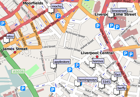
So now’s the time to go a little bit crazy and start creating favourites for some of the places you go most often. In later posts I’ll show more ways that you can use your list of favourite places to map your location when you’re out and about, there’s lots of ways now and more being created all the time. I’ll also show you how to make friends with people and how to see the history for people that you’ve already made friends with. For now though I’ll just leave you with a screengrab showing some of my favourites from the center of Liverpool:
-
Welcome to the mapme.at blog
Welcome everyone to the first post on the MapMe.at blog. I’m in Liverpool, GB as I write this, sat on the sofa at home in fact. Why would you want to know this? Well, perhaps you would like to meet up with me for a drink sometime, if you know I’m in Liverpool that might help with your planning. Perhaps you would like me to do some work for you and want to arrange a meeting, my location will help you to know whether I’m likely to be attending the meeting in person or will be on the end of a telephone.
How about another scenario, a few months ago I twittered:
Just rowed many miles down river. Barbecue now then bit more rowing to the beach.
If you know I live in Liverpool you might find that message a bit odd, have I really been rowing down the River Mersey?? In fact on that day I was halfway through a holiday to southern Turkey and we’d spent the day rowing down the Xanthos River. Being able to know my location when reading my past (or even current) twitters could obviously be useful.
Finally, here’s a snap taken when I was visiting San Francisco in May:
Most people probably know that the Golden Gate Bridge is in San Francisco, but not everyone is going to know that it’s on the South West coast of the United States. Being able to find out where I was when I took a photo is a great way of making it more interesting.
So there you have it, location is important. Being able to find out where people are now is important, being able to find out where people have been is also important. Why am I telling you this? Well this is what mapme.at is all about. I’ve been tracking my location in various ways for 2 years now. Up to a year ago I was finding it difficult to track myself as much as I would like. I setup mapme.at to try to make things easier, before mapme.at I had a single method that required me to have GPS coverage and to run a Java app on my phone. The original version of the site took this up to three separate ways of logging where I am. There are now 8 ways to log my location on mapme.at and considering one of those methods is Fire Eagle there’s potential for many more. Over the coming days I’ll be writing a few more posts to try to cover all of the ways that you can update your location here, if you’re interested in trying it out head over here for the first of these posts!
 There’s two ways you can do this. If you’re accessing your main homepage through a regular browser then when you click on a location you will see the usual “Map Me Here” button but you will also see a new flag icon. If you tap on the flag we will confirm that you want to flag the duplicate and will then save that to the system. We review these reports regularly and will merge any duplicate places together. Don’t panic! If you’ve already checked into one or the other place we will update your old check-ins to point at the correct item.


 Once you’ve decided what group you want to put someone in you need to enter their username and select the correct option. Click on the button and you’ll now be in contact with that person. They will be sent an email to inform them of the fact and be given the option to get in contact with you too. Be aware that at this point you have only given the other person the ability to see your location, you will not be able to see their location until they make contact with you. You will also need to set your permission levels, read on to find out more about that.
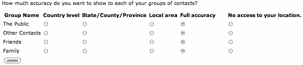

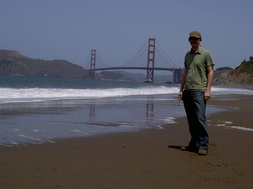 Me and the Golden Gate Bridge
subscribe via RSS